L.A. Ecology @la-county-isd @Nasa-jpl
Written on February 21, 2026 February 21st , 2026 by RashardKelly @nasa-jpl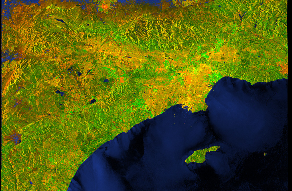
by RashardKelly @nasa-jpl
tags: 21 February 2026
1 # HOLE_TO_ANOTHER_UNiVERSE##########02/21/2026##########
2 # TO#####MsHOLLY,Hilda,Teresa,CB2,Janice&MayorKareN#####
3 # ANOTHER####Coral#######@nasa-jpl######################
4 # UNiVERSE##LA_COUNTY_MAPS#####virtiservLA____##########
Los Angeles County!
@Nasa-OPENscapes LANCE: What is the difference between Corrected Reflectance vs. Surface Reflectance Imagery?
Level 1B Calibrated Radiances - 250m
Link : 500m : 1km Temporal Coverage: 2000 FEB 24 - Present +++ Creating Reprojected True Color MODIS Images: A Tutorial - PDF @blackgirlscode @nasa-jpl @la-county-isd False Color: Red = Band 3, Green = Band 6, Blue = Band 7
This combination is used to map snow and ice. Snow and ice are very reflective in the visible part of the spectrum (Band 3), and very absorbent in Bands 6 and 7 (short-wave infrared, or SWIR). This band combination is good for distinguishing liquid water from frozen water, for example, clouds over snow, ice cloud versus water cloud; or floods from dense vegetation. This band combination is only available for MODIS (Terra) because 70% of the band 6 sensors on the MODIS instrument on the Aqua satellite failed shortly after launch.
The MODIS Corrected Reflectance imagery is available only as near real-time imagery. The imagery can be visualized in Worldview and the Global Imagery Browse Services (GIBS. The sensor resolution is 500 m and 250 m (Bands 1 and 2 have a sensor resolution of 250 m, Bands 3 – 7 have a sensor resolution of 500 m, and Bands 8 - 36 are 1 km. Band 1 is used to sharpen Band 3, 4, 6, and 7), imagery resolution is 250 m, and the temporal resolution is daily.
Snow and Ice Since the only visible light used in these images (Band 3) is assigned to red, snow and ice appear bright red. The more ice, the stronger the absorption in the SWIR bands, and the more red the color. Thick ice and snow appear vivid red (or red-orange), while small ice crystals in high-level clouds will appear reddish-orange or peach.
Vegetation Vegetation will appear green in this band combination, as vegetation is absorbent in Bands 3 and 7, but reflective in Band 6. Bare soil and deserts will appear bright cyan in the image since it much more reflective in Band 6 and 7 than Band 3.
Water Liquid water on the ground will appear very dark since it absorbs in the red and the SWIR, but small liquid water drops in clouds scatter light equally in both the visible and the SWIR, and will therefore appear white. Sediments in water appear dark red.
https://wvs.earthdata.nasa.gov/api/v1/snapshot?REQUEST=GetSnapshot&TIME=2025-01-08T00:00:00Z&BBOX=23.0107,-130.1641,38.7537,-110.5728&CRS=EPSG:4326&LAYERS=VIIRS_SNPP_CorrectedReflectance_TrueColor&WRAP=day&FORMAT=image/png&WIDTH=4458&HEIGHT=3582&colormaps=&ts=1771978285652
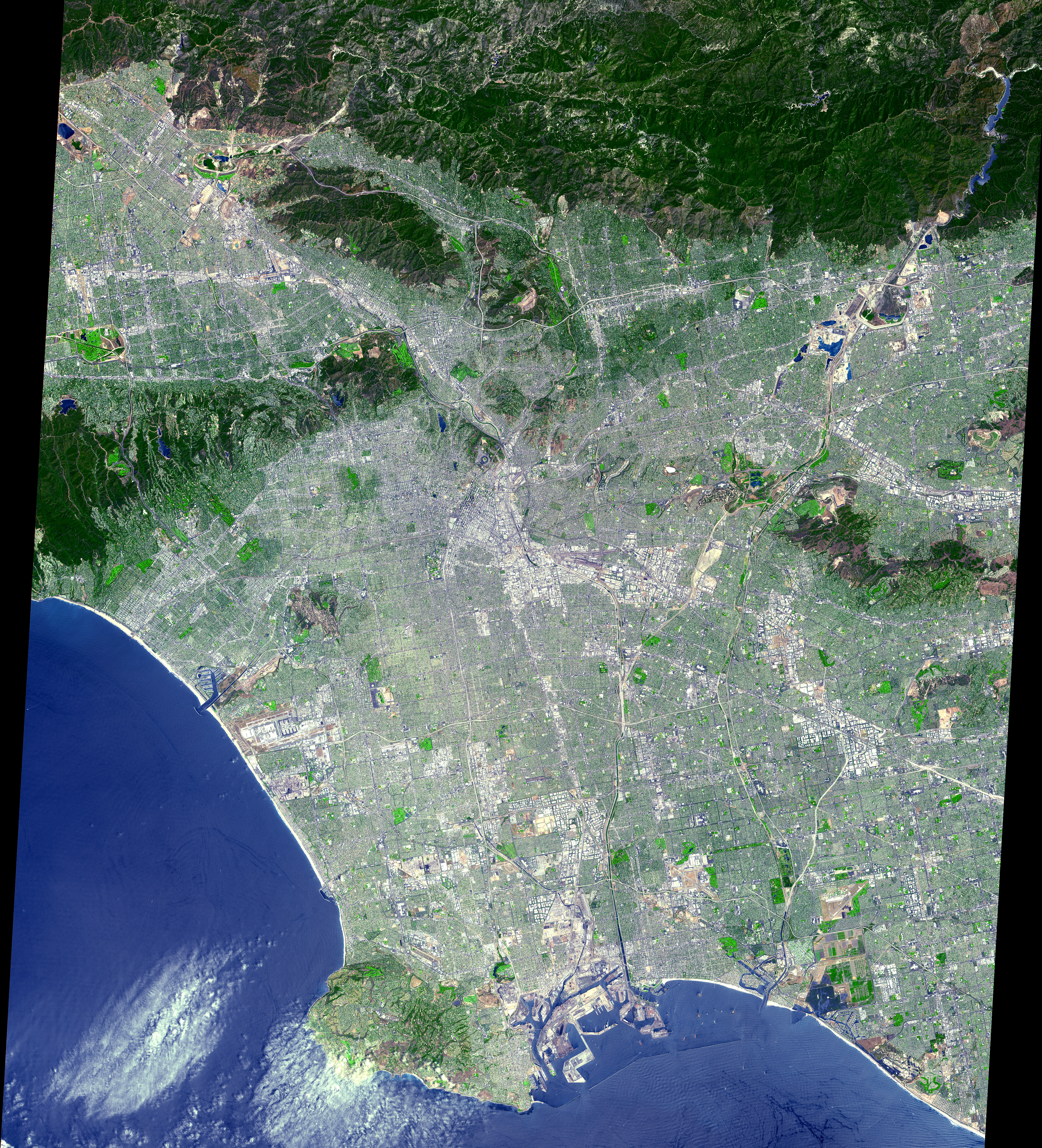
Here are is a map of Alhambra for item 22 of the past Regular Agenda - PDF pg25, the document reads that the proposed lease is exempt from the
California Environmental Quality Act. so I just wanted to contribute a few maps just incase things change because this plaCe is falling apart… @cityoflosangeles the worldviewmap is really good with closer imagery than i have ever provided rashard @nasa-jpl sup Trice ~> ThermalAnomolies
https://worldview.earthdata.nasa.gov/?v=-118.12999924887959,34.09352111791876,-118.1241181323706,34.096440234602646&l=Reference_Labels_15m,Reference_Features_15m(hidden),Coastlines_15m,HLS_False_Color_Sentinel(bandCombo=%7B%22r%22%3A%22B08%22;%22g%22%3A%22B04%22;%22b%22%3A%22B03%22;%22color_formula%22%3A%22Gamma%20RGB%202.5%20Saturation%201.2%20Sigmoidal%20RGB%2010%200.35%22;%22bands_regex%22%3A%22B%5B0-9%5D%5B0-9A-Za-z%5D%22%7D),HLS_Customizable_Sentinel(bandCombo=%7B%22r%22%3A%22B12%22;%22g%22%3A%22B8A%22;%22b%22%3A%22B04%22;%22color_formula%22%3A%22Gamma%20RGB%202.5%20Saturation%201.2%20Sigmoidal%20RGB%2010%200.35%22;%22bands_regex%22%3A%22B%5B0-9%5D%5B0-9A-Za-z%5D%22%7D),HLS_Customizable_Landsat(bandCombo=%7B%22r%22%3A%22B07%22;%22g%22%3A%22B05%22;%22b%22%3A%22B04%22;%22color_formula%22%3A%22Gamma%20RGB%202.5%20Saturation%201.2%20Sigmoidal%20RGB%2010%200.35%22;%22bands_regex%22%3A%22B%5B0-9%5D%5B0-9%5D%22%7D),MODIS_Combined_Thermal_Anomalies_Night,MODIS_Combined_Thermal_Anomalies_Day,MODIS_Combined_Thermal_Anomalies_All,MODIS_Terra_Thermal_Anomalies_Day,MODIS_Terra_Thermal_Anomalies_Night,MODIS_Terra_Thermal_Anomalies_All,VIIRS_SNPP_Thermal_Anomalies_375m_Day(hidden),VIIRS_SNPP_Thermal_Anomalies_375m_Night(hidden),World_Imagery,VIIRS_SNPP_CorrectedReflectance_TrueColor,MODIS_Aqua_CorrectedReflectance_TrueColor,MODIS_Terra_CorrectedReflectance_TrueColor&lg=false&tr=australia_fires_2019_2020&s=-118.1268,34.0952&t=2026-02-21-T23%3A59%3A51Z
@la-county-isd
@gavinNewsom @StateofCalifornia @La-CountyDPH @la-county-isd Holly Mitchell / Lindsey Horavath Please look at this map, its a shot of Los Angeles from LAndSat a couple days ago with a water analysis CLickHere - @nasa-jpl https://ladsweb.modaps.eosdis.nasa.gov/stream/map#map=9.87/-13161916.10/4041714.31&layers=aqv_chla_20260218_landsat:1.00:0.00:30.00:default,aqv_rgb_20260218_landsat:1.00:default OtherNews ++++ 2025 WildfireAnimations .zip @la-county0isd @blackgirlscode SupervisoprKathy_Latrice_saidSheIsmyVirtualAssistant/RashardKellys_DentalHealth_virtiserv_teeth_and_scabs.zip.zip //// big gif @newshour its rdar data that shows the temperature of elements and you can see fires sparking all over texas and oklahoma @caltech Checkitout -G19_sector_sp_FireTemperature_120fr_20260220-1736_VirtiservLAtrice_FireDataBae_from_Rashard_NASAJPL.gif
surface water in cyan
@la-county-isd this is a pic from the 18th @Cityoflosangeles @nasa-jpl @nasa @whitehouse @nbcla @newshour
@nasa-jpl @blackgirlscode Space Operations Update (Feb. 19, 2026)
Agency leaders are discussing the findings of investigations into the 2024 crewed test flight of Boeing Starliner to the International Space Station. Link
Electric Red Car @la-county-isd @LACMTA
https://youtu.be/lUclitPknhE?t=396
Los Angeles Pacific Electric (Red Cars) network Link @blackgirlscode @nasa-jpl wiki

By w:Pacific Electric Railway - Self-scanned, Public Domain, Link

By Pacific Electric Railway Company - Pacific Electric Railway Company materials in the Los Angeles Public Library collection, Public Domain, Link
Why Los Angeles Is Americas Most Confusing City - Architales @YouTube @la-county-isd HollyMitchell , Hilda Solis, Rep Maxine Waters //// So im listening to some sort of talk about Fifa26 [1] , likely it will be off when you check the channel [1] [ (562) 570-1122. LBTV3@longbeach.gov] <~ @emit-sds i wonder if Veronica Mcgregor knows about this audience in LongBeach?
@CityOfLosAngeles Rep Karen Bass,
im concerned about these maps of losangeles, there is a socio-political divide the entertainment industry has fueled that cuts the county out of all sorts of choices that effect our climate and comfort… As I understand what is going on I will comment more, however @Nasa-Jpl / @whitehouse says ThisISLosAngeles, a pinninsula on the coast of @StateOFCalifornia https://www.youtube.com/@architalesYT Stories about real estate, urban planning and cities! @luxelivingyt1@gmail.com //// Los Angeles from Space @nasa-jpl / jpl.nasa.gov This ASTER image was acquired on July 23, 2001 and covers an area of 64 x 72 km.

Towards global long-term water transparency products from the Landsat archive : @cityoflosangeles Mayor @ucla thats a link :: news Casey Wasserman Loses L.A Mayor’s Support For LA28 Job Over Epstein Files Revelations: “He Should Step Down” Link Mayoral Transition Advisory Team ? Link - https://jobs.lamayor.org/mayoral-transition-advisory-team @la-county-isd
@blackgirlscode Bob Marley - Rastaman Vibration (Full Album) 432hz hi brandy im starting to think you are latrice . . . @nasa-jpl i could get hurt! @whitehouse
* CALIFORNIA CONSTITUTION - CONS ARTICLE I DECLARATION OF RIGHTS [SECTION 1 - SEC. 32]
Psychological impact of false accusations of sexual abuse Some sort of satellite breaking apart and entering the atmosphere. Spotted Santa Monica Beaach
Los Angeles City Council looks into private security to deter high-rise graffiti
Is private security endangering those in California homeless shelters?
Read CaLmatteRs.orG & old data ~> @la-county-isd Read More rashardiman.github.io/civic01
Must Be dues - Melba Moore - song @blackgirlscode [1]
layout: default title: HoleToAnotherUniVersE